Pana-28
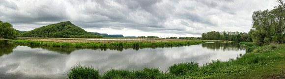
A view of Trempealeau Mountain from Perrot State Park. Surrounded by the Mississippi and Trempealeau Rivers, the steep-sided Trempealeau Mountain is one of only three solid rock islands along the entire stretch of Mississippi River. Standing 425 feet high, the mountain was used as an early navigational device by steamboat captains and other river travelers. The mountain is mostly wooded with black and white oak and basswood. Red oaks are found on the southeast-facing hollow with large patches of interrupted ferns while sugar maple and basswood dominate on the cooler northeast facing slopes. On dry south-facing slopes are small patches of dry prairie with big blue-stem, needle grass, side-oats grama, hairy grama, white and purple prairie-clover, prairie larkspur, and partridge pea. The mountain is rich in archeological features with numerous Native American mounds, burial sites, and habitation sites. The name Trempealeau comes from the French, “la montagne qui trempe à l’eau” meaning “the mountain whose foot is bathed in water”. Trempealeau Mountain is owned by the DNR, as part of Perrot State Park and was designated a State Natural Area in 2002.